Few inventions from the ancient world demonstrate the close relationship between science, engineering, government, and everyday life as clearly as the Egyptian nilometer. Long before electronic sensors, satellites, or automated river gauges, the people of ancient Egypt developed an ingenious system for measuring the annual rise and fall of the Nile River with remarkable precision. This seemingly simple structure became one of the most important technological achievements in Egyptian civilization because it helped predict harvests, determine taxation, prepare for floods, and even reinforce the authority of kings and priests. Without the nilometer, governing ancient Egypt would have been significantly more difficult.
The civilization of ancient Egypt depended almost entirely upon the Nile River. Every year, heavy seasonal rains in the Ethiopian Highlands caused the river to swell and overflow its banks hundreds of kilometers downstream in Egypt. This annual inundation deposited rich black silt across the floodplains, transforming otherwise barren desert into fertile farmland. The flood cycle was so reliable that Egyptian agriculture, economy, religion, and even their calendar evolved around it. However, although the flood arrived regularly, its height varied considerably from year to year. Too little water meant drought, crop failure, and famine, while excessive flooding could destroy villages, irrigation systems, and fields. Measuring these water levels became an essential scientific challenge.
To solve this problem, Egyptian engineers created the nilometer, a carefully designed hydraulic measuring structure built alongside the Nile. Rather than merely observing the river from the bank, the nilometer provided standardized, repeatable, and highly accurate measurements of water depth. It transformed unpredictable natural events into measurable data that could guide important governmental decisions. In many ways, it represented one of humanity's earliest examples of systematic environmental monitoring.
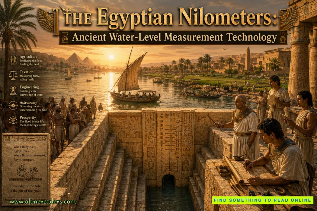
Several different designs of nilometers were developed throughout Egyptian history, reflecting advances in engineering and local geographical conditions. The most famous design consisted of a deep stone staircase descending into a well connected to the Nile through underground channels. As the river rose, water entered the chamber and gradually climbed the steps. Carefully carved markings along the walls indicated precise water levels, allowing trained officials to measure the flood height with consistency.
Another common design featured a vertical stone column standing within a cylindrical well. The column was engraved with calibrated markings representing different water levels. Water entered the surrounding chamber through underground passages, and officials observed how high the water reached on the central pillar. This pillar-style nilometer reduced turbulence caused by waves and current, improving measurement accuracy.
A third variation used interconnected underground chambers linked to the river through narrow tunnels. These structures slowed the movement of water, producing more stable readings while protecting measuring equipment from floating debris and erosion. The engineering principles behind these designs reveal an impressive understanding of hydraulic behavior, water pressure, sediment control, and structural stability.
Among the most celebrated nilometers is the structure located on Roda Island in Cairo, which dates to the early Islamic period but preserves engineering traditions inherited from ancient Egypt. Another famous example stood on Elephantine Island near Aswan, where the Nile entered Egypt after flowing north from Nubia. These locations were carefully selected because they provided representative flood measurements before the water spread across the agricultural floodplain.
Construction of a nilometer required extraordinary engineering precision. Builders excavated deep shafts into solid bedrock or constructed durable stone chambers capable of withstanding centuries of flooding. Massive limestone or granite blocks formed stable walls resistant to water erosion. Underground channels had to be carefully sized to allow water to enter smoothly without creating dangerous currents that might distort measurements. Engineers also needed to ensure that sediment accumulation did not block these channels over time, requiring periodic maintenance.
The engraved measuring scales represented one of the earliest standardized calibration systems in history. Rather than relying upon subjective observation, officials could compare the water level against permanent reference marks carved into stone. These markings were commonly expressed using the Egyptian cubit, an established unit of measurement approximately 52 centimeters in length. Standardization allowed measurements taken in different years to be directly compared, creating valuable historical records spanning generations.
The work of monitoring the nilometer was entrusted primarily to priests and specially trained government officials. Their responsibilities extended far beyond simply reading numbers. Every day during the flood season, measurements were carefully recorded and reported to royal administrators. The information became an essential component of state planning. Ancient Egypt effectively operated one of the world's earliest environmental data collection systems.
Accurate flood measurement directly influenced agriculture. Farmers needed sufficient warning to prepare irrigation canals, repair dikes, organize planting schedules, and allocate labor efficiently. If the nilometer indicated a low flood, authorities could anticipate poor harvests and make preparations to manage food shortages. Conversely, exceptionally high readings warned communities to reinforce flood defenses and protect settlements from destructive overflow.
Perhaps the most remarkable use of nilometer data involved taxation. Ancient Egyptian governments understood that agricultural production depended heavily upon the flood level. Therefore, tax assessments often reflected the expected harvest predicted by nilometer readings. A strong flood generally promised abundant crops, allowing higher taxes without threatening farmers' survival. Poor floods resulted in reduced agricultural output, making excessive taxation both unfair and economically dangerous. The nilometer therefore linked natural science directly with public administration and economic policy.
Religious belief further enhanced the importance of these remarkable structures. Egyptians regarded the Nile as a divine gift closely associated with gods such as Hapi, the deity representing the annual inundation. The flood symbolized renewal, fertility, and cosmic order. Measuring the river therefore carried religious significance as well as scientific value. Ceremonies often accompanied the beginning of the flood season, and priests interpreted the rising water as evidence of divine favor or warning.
Interestingly, while religious rituals surrounded the flood, the actual measurement process remained fundamentally practical and empirical. Officials depended upon physical observations rather than supernatural predictions. This combination of religious tradition with systematic measurement illustrates the unique intellectual character of ancient Egyptian civilization, where spiritual beliefs and practical engineering frequently coexisted rather than conflicted.
The nilometer also demonstrates the impressive mathematical abilities of Egyptian engineers. Designing underground channels with appropriate gradients required understanding water flow characteristics. Builders had to account for seasonal changes, sediment transport, structural loading, and long-term durability. The consistency of surviving nilometers indicates that their creators possessed considerable expertise accumulated through centuries of practical experience.
Maintenance formed another critical aspect of nilometer operation. Sediment deposited by the Nile could gradually obstruct channels or cover measuring marks. Officials therefore organized regular cleaning, repairs, and recalibration. Stone surfaces occasionally required restoration to preserve the accuracy of engraved measurement lines. Such maintenance ensured that observations remained reliable over many generations.
Historical records suggest that particularly favorable flood levels became famous events remembered for decades. An ideal inundation balanced abundant water with manageable flood heights, maximizing agricultural productivity while minimizing destruction. These records contributed to long-term planning and helped administrators recognize patterns across multiple years. Although ancient Egyptians lacked modern hydrological theory, they developed an impressive understanding of environmental variability through careful observation.
The technological significance of the nilometer extends beyond Egypt itself. It represents one of humanity's earliest examples of an engineered monitoring instrument specifically designed to quantify natural phenomena. Modern river gauges, reservoir sensors, flood forecasting systems, and hydrological monitoring stations all perform functions conceptually similar to those pioneered thousands of years ago along the Nile. The principles of standardized measurement, calibration, long-term record keeping, and evidence-based decision making remain fundamental to modern engineering.
Many nilometers survived for centuries because of their exceptional construction quality. Archaeologists studying these structures have gained valuable insights into ancient engineering methods, surveying techniques, and stone construction practices. The precision of carved measurement scales demonstrates remarkable craftsmanship, while underground passages reveal sophisticated knowledge of hydraulic engineering that continues to impress modern researchers.
The legacy of the Egyptian nilometer lies not merely in its physical design but in the philosophy it represented. Ancient Egyptian engineers recognized that understanding nature required careful observation, consistent measurement, and accurate record keeping. Rather than viewing the Nile as an unpredictable force beyond human comprehension, they developed technology that transformed its behavior into usable information. This shift from simple observation to systematic measurement marked an important milestone in the history of science and engineering.
Today, the surviving nilometers stand as enduring monuments to one of history's most practical inventions. They remind us that great engineering achievements are not always massive pyramids or monumental temples. Sometimes the most revolutionary technologies are those that quietly improve everyday life by providing reliable knowledge. For thousands of years, these elegant stone structures enabled rulers to govern wisely, farmers to cultivate successfully, engineers to manage water resources, and entire communities to thrive beside one of the world's greatest rivers. In their combination of precision, durability, and practical usefulness, the Egyptian nilometers remain one of the finest examples of ancient engineering serving both civilization and science.

October 25, 2023

January 02, 2025




 The Hagia Sophia Dome: Byzantine Earthquake-Resistant Engineering That Defied Time
 The Stepwells of India: Hydraulic Architecture for Monsoon Survival and Ancient Water Engineering
 Romania Enters World War I: Ambition, Defeat, and Survival on the Eastern Front
 The Armenian Genocide During World War I: Deportation, Mass Killing, and Historical Legacy
 The Arab Revolt Against the Ottoman Empire: War, Nationalism, and Betrayal
 The House of Plantagenet: Rise, Golden Age, and Fall of England's Longest-Reigning Feudal Dynasty
 The Rise and Fall of the Ptolemaic Dynasty: Cleopatra's Last Stand Explained
 The Macedonian Dynasty Explained: Alexander's Expansion and the Dissolution of His Empire
 The Achaemenid Persian Empire: Royal Road Power, Imperial Expansion, and the Greek Defeat That Changed History