Between Denmark and Sweden lies one of the most ingenious transportation links ever built. From a distance, the Øresund Bridge appears to be an enormous cable-stayed bridge stretching confidently across the sea. Yet anyone following the route toward Denmark encounters something unusual. The bridge approaches a low artificial island and then seems to disappear. The motorway and railway descend toward sea level and ultimately continue beneath the Øresund Strait through an immersed tunnel.
This apparent transformation from bridge to underwater passage is not an architectural trick. It is the central engineering concept behind the Øresund fixed link, a combined road-and-rail connection joining the Copenhagen region of Denmark with Malmö in southern Sweden.
The complete crossing is much more than a bridge. It is an integrated transportation system consisting of a bridge, an artificial island, an immersed tunnel, motorway infrastructure, and an electrified railway. Together, these components solved a difficult engineering problem: how to create a permanent high-capacity connection between two countries while simultaneously accommodating ships, aircraft, railways, automobiles, and a sensitive marine environment.
The result is a structure that demonstrates an important principle of large-scale engineering: sometimes the best bridge is one that does not remain a bridge for its entire journey.
The idea of permanently connecting Denmark and Sweden existed long before construction began. Copenhagen and Malmö face each other across the Øresund, a narrow but strategically important body of water connecting the Baltic Sea with the Kattegat and, ultimately, the North Sea.
For generations, ferries carried passengers, vehicles, and freight between the two countries. Ferry transportation worked, but it imposed unavoidable limitations. Ships were slower than a direct road or railway connection, their capacity was finite, and journeys depended on terminals, loading procedures, and sailing schedules.
A fixed crossing promised something fundamentally different. Trains could travel directly between the Danish and Swedish railway networks, while cars and trucks could move continuously between Copenhagen and Malmö.
The project therefore had implications far beyond shortening a journey across the water. It had the potential to integrate labor markets, businesses, transportation networks, airports, universities, and communities on opposite sides of an international border.
The governments of Denmark and Sweden eventually reached an agreement to construct the permanent connection. Major construction operations began during the 1990s, and the Øresund fixed link officially opened to traffic in July 2000.
Creating a bridge across the entire strait might initially seem like the simplest solution. Engineers could theoretically have constructed a continuous sequence of approach spans leading to a high central navigation span.
The geography and infrastructure around Copenhagen, however, made that solution problematic.
One of the greatest constraints was Copenhagen Airport, located immediately beside the Danish end of the crossing. A very tall bridge close to the airport could interfere with aircraft approach and departure corridors. Large bridge towers would introduce permanent vertical obstacles into an area where aviation safety demands carefully controlled clearances.
Shipping created another challenge. The Øresund is an important maritime route. Any permanent crossing needed to preserve safe navigation and avoid creating unacceptable restrictions for vessels moving through the region.
These competing requirements produced the project's defining solution.
Instead of forcing one structural type across the entire strait, engineers divided the crossing according to local conditions. A large bridge would handle the Swedish side. An artificial island would provide the transition point. The route would then descend underground and continue beneath the Danish side through a tunnel.
This arrangement allowed engineers to exploit the advantages of bridges where bridges made sense and tunnels where tunnels offered greater operational freedom.
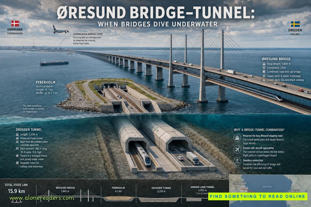
The bridge portion extends for approximately 7.8 kilometers from the Swedish coast toward the artificial island of Peberholm. It incorporates long approach structures and an impressive cable-stayed central section.
Its most recognizable features are the enormous pylons rising above the Øresund. The main cable-stayed span stretches approximately 490 meters, providing substantial clearance for maritime traffic beneath it.
But the bridge is unusual not simply because of its size.
It carries two different transportation systems on two levels.
Road vehicles use the upper deck, while trains travel on the lower level. This double-deck arrangement allowed engineers to accommodate motorway and railway traffic within the same primary structure rather than building independent crossings.
Structurally, that decision required careful consideration of very different loading patterns. Highway traffic produces constantly changing concentrations of cars and heavy trucks. Railway vehicles impose large, repetitive axle loads along precisely defined tracks. Wind acts on the entire exposed bridge, while trains and road vehicles must remain safe and stable during Scandinavian weather conditions.
The structure therefore had to combine stiffness, aerodynamic stability, fatigue resistance, durability, and sufficient flexibility to accommodate temperature changes and normal structural movement.
The marine environment created another long-term challenge. Saltwater and salt-laden air can accelerate corrosion of steel reinforcement, cables, structural components, and mechanical systems. Major maritime bridges must therefore be designed not simply to survive their opening day but to withstand decades of exposure while remaining inspectable and maintainable.
Traveling from Sweden toward Denmark, the bridge eventually reaches what looks like an unusually flat strip of land surrounded by water.
This is Peberholm, an artificial island created specifically as part of the Øresund project.
Peberholm performs a critical engineering function. A bridge cannot simply plunge vertically into the sea. Roads and railways have strict limits on acceptable gradients, particularly railway lines carrying heavy and high-speed traffic. The infrastructure therefore requires substantial horizontal distance to descend gradually.
Peberholm provides that transition zone.
The bridge approaches the island, and the transportation corridor progressively moves downward until it can enter the tunnel leading beneath the water toward Denmark.
The island is roughly four kilometers long and was constructed largely from material excavated or dredged during the project. Its elongated shape provides sufficient distance for the motorway and railway to change elevation without excessive gradients.
Peberholm also became an unusual ecological experiment. Rather than developing the island extensively or landscaping it like a conventional infrastructure site, authorities largely allowed natural ecological processes to determine how vegetation and wildlife colonized the new land.
Thus, an artificial structure built to solve a transportation problem gradually developed ecological significance of its own.
Beyond Peberholm, the most fascinating part of the crossing begins.
The motorway and railway enter the Drogden Tunnel, which carries the connection beneath the sea toward the Danish island of Amager.
Unlike a tunnel excavated deep underground by a tunnel-boring machine, Drogden is an immersed tube tunnel.
This construction method works very differently from conventional bored tunneling.
Instead of drilling horizontally through rock or soil, engineers manufacture enormous watertight tunnel sections, transport them to the required location, sink them into a prepared trench on the seabed, connect them underwater, and then protect them with surrounding and overlying material.
For the Øresund project, enormous reinforced-concrete tunnel elements were fabricated under controlled conditions. Each section represented a massive piece of infrastructure containing the spaces that would ultimately form the road and railway corridors.
Meanwhile, dredging equipment prepared a trench along the planned tunnel alignment.
The completed tunnel elements were sealed temporarily so they could float. They were then transported to their designated positions above the trench.
The sinking process demanded exceptional precision.
By carefully controlling ballast, engineers lowered each giant element toward the seabed. Positioning systems and specialized marine equipment guided it into alignment with the previously installed section.
The elements then had to be joined into a continuous watertight structure.
Once the connection between sections was secured and verified, the tunnel could be surrounded and protected by appropriate seabed materials. Internally, the roadway, railway, ventilation, electrical systems, drainage, fire protection, communications equipment, emergency facilities, and other infrastructure transformed the concrete shell into an operational transportation tunnel.
The immersed portion of the Drogden Tunnel extends for approximately 3.5 kilometers, while the overall tunnel system, including portal sections, extends farther.
Inside, road and railway traffic occupy separate spaces. The arrangement includes two motorway tubes and two railway tubes, together with a central service and emergency passage.
That separation is important for both routine operation and emergency management. A modern subsea transportation tunnel must be treated as an integrated safety system rather than merely as a concrete passage beneath water.
Ventilation must control normal vehicle emissions and respond appropriately during emergencies. Drainage systems must manage water infiltration and operational runoff. Fire detection, communications, lighting, monitoring, emergency access, and evacuation arrangements must continue functioning under demanding conditions.
Railway operations introduce another layer of complexity because the rail system must integrate signaling, electrical supply, communications, and safety requirements across an international boundary.
The fixed link consequently represents much more than civil engineering. It combines structural engineering, geotechnical engineering, marine construction, transportation engineering, railway systems, electrical engineering, aviation constraints, navigation requirements, environmental planning, and international coordination.
Perhaps the most elegant part of the entire project is that travelers may barely notice the transition between these enormous engineering systems.
A motorist leaving Sweden drives onto what appears to be a conventional motorway bridge. The roadway crosses long approach spans and the dramatic cable-stayed section high above the water. It then reaches Peberholm and begins descending. The horizon gradually changes, retaining walls rise alongside the route, and the roadway enters the tunnel.
Within minutes, the same journey has moved from an elevated bridge deck exposed to wind and open sky to a reinforced-concrete passage beneath the seabed.
Rail passengers experience the same structural transformation below the motorway deck.
This seamless transition hides the enormous complexity behind it.
The crossing also illustrates why engineers rarely choose infrastructure solely according to what looks most spectacular. A complete bridge might have created a more visually continuous monument, but engineering projects must respond to operational constraints.
A tunnel near Denmark reduced concerns associated with tall bridge structures near Copenhagen Airport. The bridge on the Swedish side provided an efficient and economically practical way of spanning open water while maintaining a major navigation channel beneath the central span. Peberholm provided the physical distance necessary to connect the two systems.
Each component solves a different problem.
Together, they form one coherent transportation corridor.
The Øresund connection also reshaped regional geography in a practical sense. Copenhagen and Malmö had always been geographically close, but water and ferry operations created a substantial transportation boundary between them. The fixed link dramatically reduced that barrier.
Rail services could connect the urban centers directly, while road traffic gained continuous motorway access. Copenhagen Airport became more accessible from southern Sweden, and commuting across the international border became realistic for many workers.
Freight movements also benefited from a permanent road and railway connection linking Scandinavia more closely with continental European transportation networks.
The project therefore demonstrates how infrastructure can alter the functional meaning of geography. Two cities separated by an international strait can begin behaving more like parts of a connected metropolitan region when transportation time and complexity decline.
Its engineering significance is equally important.
The Øresund fixed link rejects the idea that a megaproject must rely on a single spectacular structural solution. Instead, it demonstrates the power of hybrid infrastructure.
Bridges are exceptionally effective at crossing water when foundations can be constructed economically and adequate clearance can be provided. Tunnels are valuable when surface obstacles, aviation requirements, urban development, environmental constraints, or navigation considerations make bridges difficult. Artificial islands can provide construction platforms, transition zones, ventilation sites, or alignment solutions.
The Øresund project combines all three.
Its bridge rises above the sea. Its artificial island creates new ground where none naturally existed. Its tunnel disappears beneath the seabed. Its motorway and railway operate as parallel transportation arteries linking national networks.
The visual effect is unforgettable: an enormous bridge appears to descend toward a narrow island and vanish into the water.
Yet the true achievement is not the illusion of a bridge diving beneath the sea. It is the disciplined engineering behind that transition.
Every kilometer reflects a different constraint. Shipping demanded clearance. Aviation discouraged tall structures near Copenhagen Airport. Railways required manageable gradients. Motorways demanded capacity and safety. The marine environment required durability. International transportation required compatible operational systems. Environmental concerns required careful management of the surrounding strait.
Instead of allowing those constraints to defeat the project, engineers used them to determine its form.
That is why the Øresund Bridge–Tunnel remains one of the clearest examples of integrated infrastructure engineering in the modern world. Its elegance comes not from using the largest possible bridge or the deepest possible tunnel, but from placing each type of structure exactly where it performs best.
Above the Øresund, the crossing looks monumental. Beneath it, the engineering becomes almost invisible. Between those two worlds lies Peberholm, the artificial island that makes the transformation possible.
The result is a remarkable journey in which a motorway and railway leave Sweden on a bridge, cross an island built by engineers, disappear beneath the sea, and emerge in Denmark—turning what was once a maritime boundary into one of Europe's most extraordinary transportation corridors.




 Château de Carcassonne: Europe’s Greatest Medieval Citadel and Fortress
 Château de Chenonceau: The Castle Built by Remarkable Women
 Château de Chambord: France’s Magnificent Renaissance Castle and Architectural Wonder
 Tehri Dam: India's Tallest Dam and the Debate Behind It
 Bhakra Nangal Dam: India's Temple of Modern Development
 Mangla Dam: Pakistan's Second Great Water Project