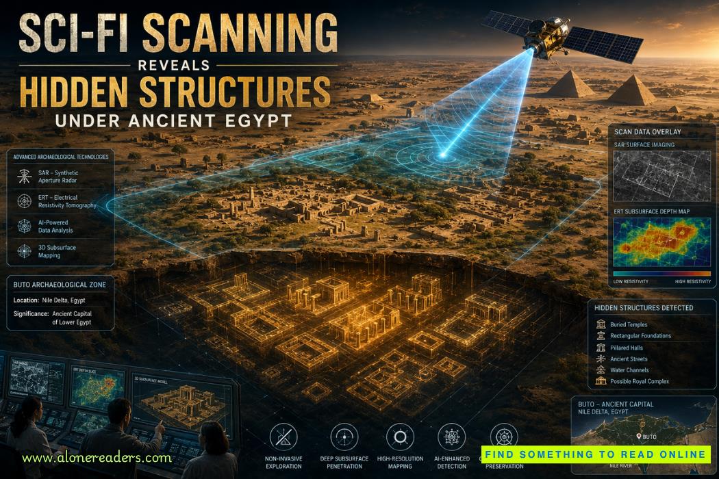
A radar pulse sliced through the sand long before any archaeologist lifted a spade. Beneath the surface of Egypt’s long-abandoned city of Buto, geometric walls and buried chambers emerged on-screen as bright signatures—structures unseen for thousands of years, suddenly revealed through a technology that feels closer to science fiction than traditional fieldwork. This discovery represents a turning point: ancient Egypt scanning technology is uncovering a hidden landscape that excavation had never reached.
Key Takeaways
Archaeologists studying Buto received something unprecedented: a detailed map of what lay beneath the site before they even began excavation. Radar signatures showed continuous architectural lines, rectangular rooms, and voids that followed the logic of human construction rather than natural geology. Instead of isolated anomalies, the imaging suggested a district—possibly part of an administrative or ritual complex—that had been lost under layers of Nile silt.
This shift reverses a century-long archaeological pattern. Instead of digging to map a city, researchers now map the city to decide where to dig. The difference is profound. Before, excavation was an act of discovery; now it is confirmation.
The buried Egyptian city of Buto has long been associated with Lower Egypt’s earliest cultural identity. Yet its layout remained fragmented because only small areas had ever been excavated. The new scanning pass stitched these fragments together with remarkable clarity, revealing alignments that only large-scale imaging could detect.
To grasp why the Buto Egypt discovery is so significant, it helps to understand the science behind it. Satellite radar archaeology, often powered by Synthetic Aperture Radar (SAR), works by sending microwave pulses toward the ground. These pulses interact differently with sand, moisture, stone, and buried architecture.
When the radar beam penetrates the upper soil layers, it bounces differently off compacted mudbrick, limestone foundations, or voids left by collapsed roofs. These reflections create patterns that analysts interpret as potential structures.
SAR excels because it can:
In environments like the Nile Delta—where flooding deposits layers of silt—SAR identifies density changes far below the surface. Foundations that would take years of targeted digging to locate instead appear as crisp radar signatures etched across the digital landscape.
As Egypt’s desert becomes increasingly digitized, SAR is revealing not only buildings but also ancient pathways, canals, and the outlines of long-vanished settlements.
If SAR is the overview, Electrical Resistivity Tomography (ERT) is the close-up inspection. Instead of radar waves from the air, ERT sends electrical currents through the earth. Different materials resist electricity at different levels. Stone walls resist; clay conducts more; empty chambers resist strongly because they contain air.
When archaeologists feed this data into modeling software, the result is a vertical and horizontal map of what lies beneath the surface.
ERT can detect:
At Buto, ERT complemented SAR by confirming the depth, dimensions, and orientation of the buried complex. Together, these technologies produced a cross-sectional understanding of the city that traditional archaeology could not achieve in such a short time.
The pairing of SAR and ERT forms a comprehensive non-invasive archaeology toolkit, merging aerial imagery with subterranean mapping. The outcome is something archaeologists once only imagined: a structural blueprint of an ancient city before the first trench is opened.
Buto was not a marginal town; it was once a thriving cultural center of Lower Egypt, predating the unification of the kingdom. Associated with the goddess Wadjet and early dynastic power, the site held political and religious authority long before the pyramids rose along the Nile.
Buto’s importance lies in three historical roles:
And yet, for decades, Buto remained an archaeological puzzle. Flood deposits, agricultural expansion, and limited excavation confined discoveries to scattered pockets. Entire districts remained unknown.
The new findings suggest Buto may have had a larger administrative and ritual landscape than previously assumed. By revealing walls, storage structures, and possible temple platforms, the scans hint at a more complex urban identity—one that challenges older models that portrayed the site as less developed than Upper Egyptian centers.
The buried Egyptian city discovered through SAR and ERT may redefine the role of the Delta in shaping Egypt’s earliest state formation.
One of the most transformative implications of these technologies is their potential to change how archaeologists search for tombs. Egypt’s deserts still hold many unlocated burials, from high-ranking officials to lesser-known rulers. Traditional excavation is slow, expensive, and restricted to narrow trenches.
Non-invasive scanning flips the process by offering large-scale visibility before physical work begins.
SAR helps identify:
ERT adds confirmation by showing whether a void is empty, filled with collapsed material, or lined with stone. For royal and elite burials—especially those buried outside well-studied zones—these clues can drastically narrow search areas.
For example, tomb shafts often produce a unique signature: a vertical anomaly with low electrical resistance surrounded by higher-resistance stone or compacted soil. In radar imaging, they appear as small but consistent geometric disruptions distinct from natural formations.
This approach saves resources and reduces unnecessary excavation. It also protects fragile heritage. Many ancient structures collapse when exposed, so knowing their exact geometry in advance allows archaeologists to plan safer and better-supported excavations.
As scanning resolution improves, it may even become possible to distinguish materials—mudbrick versus limestone, empty chambers versus filled ones—before opening the site.
These new tools have generated excitement, but they have also produced misconceptions.
Yet even with limitations, the precision and scale of SAR and ERT far surpass older survey methods. They add a much-needed layer of predictability to excavation planning.
The discovery at Buto is not an isolated example. Scanning technology is increasingly revealing long-lost architectural networks across Egypt. In several regions, radar passes have identified entire settlement grids erased by desert winds. In others, ERT has uncovered subsurface waterways that once fed agricultural communities.
The cumulative effect is a radical reimagining of Egypt’s human geography. Rather than isolated temple sites surrounded by empty desert, researchers now see complex cities with neighborhoods, industrial zones, and ceremonial spaces.
This depth of understanding was once impossible without destructive digging. Now, a digital map precedes every excavation, ensuring that archaeology becomes more strategic and less invasive.
The combination of satellite radar archaeology and ground-based ERT marks a convergence of science, history, and engineering. It turns the earth into a readable archive, layer by layer.
The Buto Egypt discovery is a reminder that the sands still guard an astonishing amount of unexplored history. With each radar pass and resistivity scan, Egypt becomes more transparent. We are entering an era when archaeologists can detect temples, workshops, and entire districts without disturbing a single grain of sand.
As non-invasive archaeology continues to advance, one question becomes unavoidable:
How many ancient structures are already visible to machines, waiting for us to look?
What technology is revealing hidden Egyptian structures?
Answer: Synthetic Aperture Radar and Electrical Resistivity Tomography are used to detect buried architecture non-invasively.
What did researchers find under Buto?
Answer: They identified geometric foundations and voids suggesting temples, workshops, or administrative buildings.
How does satellite radar archaeology work?
Answer: It analyzes radar signals that penetrate soil layers and detect anomalies shaped like human-built structures.
Why is non-invasive archaeology important?
Answer: It allows archaeologists to map sites without extensive excavation, protecting fragile heritage.
Can these systems detect undiscovered tombs?
Answer: They can reveal patterns, voids, and subterranean anomalies, guiding excavations toward likely tomb sites.

October 25, 2023

January 02, 2025

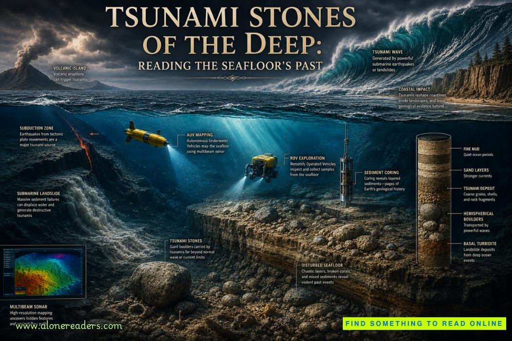 Tsunami Stones of the Deep: Reading the Seafloor's Geological Memory
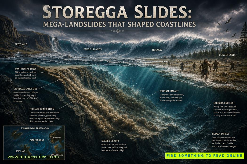 Storegga Slides: Mega-Landslides That Shaped Coastlines and Changed Prehistoric Europe
 Submarine Canyons: The Grand Canyons of the Continental Shelf and Their Hidden Ocean Worlds
 Seamount Oases: Biodiversity Hotspots in the Blue Desert | Hidden Mountains of the Deep Ocean
 Jeddah Light: One of the Tallest Modern Lighthouses in the World and a Gateway to the Red Sea
 Inisheer Lighthouse: Ireland's Quiet Island Beacon Guarding the Edge of the Atlantic
 The Abu Ghraib Scandal, Iraq, 2004: A Human Rights Disaster That Shook the World
 The Disbanding of the CNRP, Cambodia, 2017: Hun Sen's Clampdown on Democracy and the Reshaping of Cambodian Politics
 The Firing of James Comey, United States, 2017: Trump's Controversial Decision Amid FBI Investigation
 The Rwandan Refugee Crisis, Central Africa, 1994: Aftermath of Genocide and the Humanitarian Catastrophe
 The Most Important Turning Points of the Battle of Hastings (1066)
 Why William Won the Battle of Hastings and Harold Lost: Strategy, Leadership and Fate in 1066
 How King Harold II Died: Facts, Myths, and Historical Debate
 The Battle of Hastings: A Complete Timeline of the Fighting
 High-End Talent Category A Work Permit China 2026: Complete Eligibility, Benefits, Application Process, and Expert Guide
 Cultural Activities Visa Japan 2026 Guide: Complete Eligibility, Requirements, Application Process, and Expert Tips