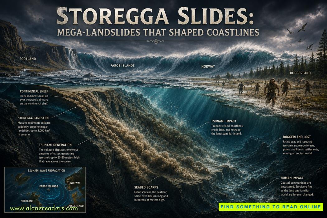
The modern coastlines surrounding the North Atlantic appear permanent, but beneath the cold waters west of Norway lies overwhelming evidence that entire continental margins can fail catastrophically within hours. Among the greatest geological disasters ever discovered is the Storegga Slides, a sequence of enormous submarine landslides that occurred along the continental shelf edge approximately 8,150 years ago. These collapses displaced thousands of cubic kilometers of sediment, generated massive tsunamis, reshaped coastlines across northern Europe, and likely accelerated the final disappearance of low-lying prehistoric landscapes that connected Britain to continental Europe.
Unlike earthquakes or volcanic eruptions, submarine landslides remain largely invisible while they occur. Hidden beneath hundreds of meters of seawater, these colossal failures can mobilize sediment over distances exceeding several hundred kilometers. Yet despite occurring underwater, their consequences are anything but isolated. The Storegga event demonstrates how geological processes beneath the sea floor can instantly transform distant coastlines, alter ecosystems, and profoundly influence human populations living hundreds of kilometers away.
The Norwegian Continental Shelf
The Storegga region lies along the continental margin off western Norway between the Norwegian Sea and the North Atlantic Ocean. Over millions of years, glaciers repeatedly advanced across Scandinavia, grinding enormous volumes of rock into fine sediment. During each ice age, these sediments were transported toward the continental shelf and deposited layer upon layer beneath the ocean.
As glaciers retreated after the Last Glacial Maximum, sediment continued accumulating at extraordinary rates. Thick deposits of clay, silt, sand, and glacial debris gradually built unstable submarine slopes. While these underwater landscapes appeared stable for thousands of years, geological conditions were steadily preparing them for catastrophic collapse.
An Unstable Geological Foundation
The continental slope beneath Storegga consisted of alternating strong and weak sediment layers. Some layers contained water-rich marine clays capable of losing strength rapidly when disturbed. Others trapped large quantities of pore water, reducing friction between sediment particles.
This geological architecture created conditions similar to stacking heavy objects on slippery surfaces. Although the deposits remained intact for centuries, relatively small disturbances could eventually trigger widespread failure.
Around 6200 BCE, a massive section of the continental margin suddenly failed. Rather than a single localized collapse, the Storegga Slides involved several enormous failures that propagated downslope across vast areas of the seabed.
Scientists estimate that roughly 3,000 to 3,500 cubic kilometers of sediment were displaced. To appreciate this scale, the volume exceeded many of the world's largest mountain ranges if compressed into a single mass.
The landslide scar stretches approximately 290 kilometers along the continental shelf and extends over 800 kilometers downslope into the deep ocean basin. Some sediment traveled hundreds of kilometers before finally coming to rest.
The event ranks among the largest submarine landslides ever identified anywhere on Earth.
Dimensions Beyond Human Experience
The Storegga Slides affected an area exceeding 95,000 square kilometers.
Key estimates include:
Even modern engineering projects cannot approach this scale. Entire mountain-sized masses of sediment essentially flowed like thick liquid across the seabed.
Determining the exact trigger remains one of marine geology's greatest research questions. Most scientists believe multiple factors combined to produce the failure.
Post-Glacial Sediment Loading
Following the retreat of Scandinavian ice sheets, enormous quantities of sediment accumulated unusually rapidly. The additional weight increased stress on deeper sediment layers.
Earthquake Activity
The removal of massive glaciers caused the Earth's crust to rebound upward. This post-glacial adjustment generated earthquakes across northern Europe. Even moderate seismic shaking may have destabilized already fragile submarine slopes.
Gas Hydrate Destabilization
One long-standing hypothesis involves methane hydrates.
Gas hydrates are crystalline compounds where methane molecules become trapped within ice-like structures under high pressure and low temperature. Changes in pressure or temperature may destabilize these deposits, releasing methane gas and weakening surrounding sediments.
Although researchers continue debating the significance of hydrates during the Storegga event, they remain one possible contributing factor.
Excess Pore Water Pressure
Water trapped within fine-grained sediments reduces friction between particles. As pressure increases, sediment layers become increasingly susceptible to sudden failure.
Rather than requiring a dramatic trigger, some slopes may simply reach a critical threshold where even minor disturbances initiate collapse.
Perhaps the most dramatic consequence of the Storegga Slides was the enormous tsunami generated by the collapsing seabed.
When thousands of cubic kilometers of sediment suddenly moved downslope, they displaced vast quantities of seawater. The resulting waves radiated across the North Atlantic basin.
Unlike wind-generated waves, tsunami wavelengths extend for hundreds of kilometers. Their energy penetrates the entire water column, allowing them to travel immense distances with relatively little energy loss.
As these waves approached shallow coastal waters, they slowed while increasing dramatically in height.
Modern understanding of the Storegga tsunami comes from remarkable geological evidence preserved across northern Europe.
Scotland
Sand deposits containing marine shells occur far inland above modern sea level along eastern Scotland.
These sediments appear abruptly within peat deposits, indicating sudden marine flooding rather than gradual sea-level rise.
In several locations, tsunami deposits occur over 20 meters above contemporary sea level.
Norway
Along western Norway, marine sediments associated with the tsunami occur within ancient coastal environments.
These deposits contain distinctive mixtures of offshore sand, shell fragments, and coastal material transported inland by exceptionally powerful waves.
Faroe Islands
Evidence suggests tsunami waves reached the Faroe Islands despite their considerable distance from the collapse zone.
Marine sediments appear within otherwise terrestrial environments, supporting widespread flooding.
Shetland Islands
The Shetland Islands preserve some of the clearest tsunami deposits anywhere in Europe. Thick sand layers extend inland beyond normal storm limits, demonstrating wave energy far exceeding ordinary coastal processes.
One of the most fascinating aspects of the Storegga Slides involves their relationship with Doggerland.
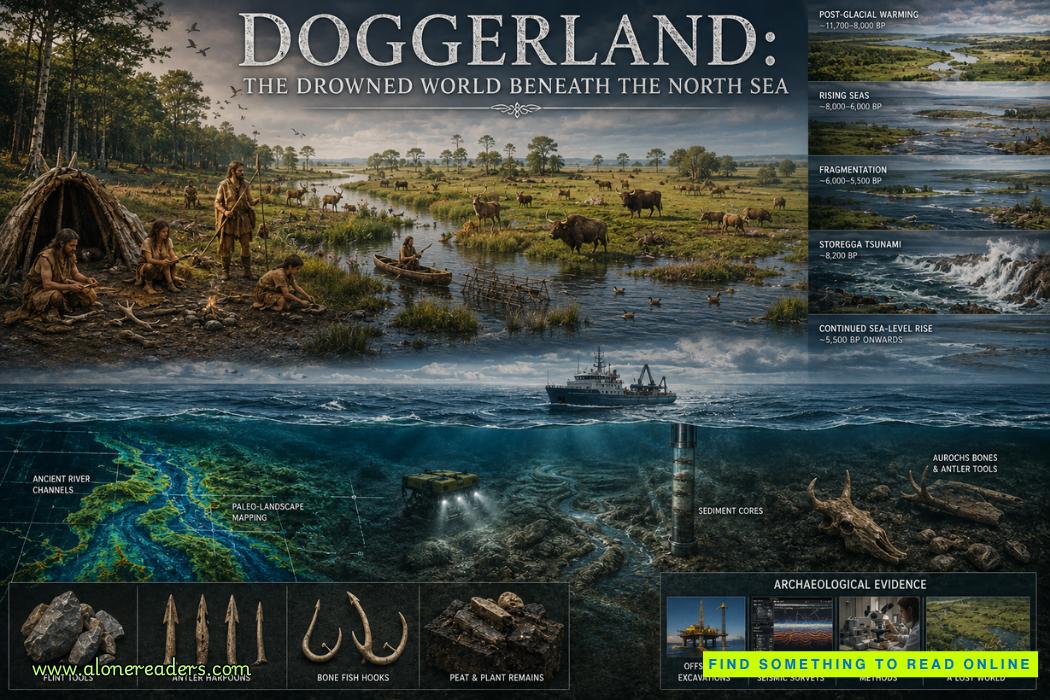
Doggerland was an extensive low-lying plain connecting Britain to mainland Europe after the last Ice Age. Rivers crossed forests, marshes, lakes, and grasslands that supported abundant wildlife and Mesolithic hunter-gatherer communities.
Sea levels had already been rising gradually due to melting glaciers, reducing the size of Doggerland over centuries.
The Storegga tsunami likely inundated large remaining portions of this landscape.
Although the tsunami probably did not eliminate Doggerland entirely in a single day, it almost certainly devastated coastal settlements, altered river systems, destroyed freshwater habitats, and accelerated abandonment of vulnerable lowlands.
For prehistoric communities with no understanding of geological hazards, the event would have appeared as an unimaginable catastrophe.
Wave heights varied significantly depending on coastal geography.
Numerical simulations suggest:
Because tsunami behavior depends heavily upon underwater topography, neighboring coastlines could experience dramatically different impacts.
The tsunami itself lasted only hours, but its geological effects persisted for millennia.
Coastal Erosion
Powerful waves stripped vegetation, removed soils, and eroded cliffs.
Fresh sediment deposits altered shoreline configurations and changed coastal drainage patterns.
Wetland Destruction
Saltwater intrusion transformed freshwater marshes into saline environments.
Many plant communities required centuries to recover.
River Modification
Large waves temporarily reversed river flow, depositing marine sediment far upstream.
Some river mouths changed position permanently after the event.
Marine and terrestrial ecosystems experienced major disruptions.
Coastal forests suffered saltwater damage.
Estuarine habitats changed dramatically.
Freshwater lakes became contaminated with seawater.
Animal populations dependent upon coastal wetlands lost important feeding grounds.
At the same time, newly deposited sediments eventually created fresh habitats that later supported different ecological communities.
Nature recovered, but not immediately.
Understanding an event that occurred more than eight thousand years ago requires multiple scientific disciplines working together.
Marine Geophysical Surveys
High-resolution sonar maps reveal the enormous landslide scar across the continental margin.
Three-dimensional seismic imaging allows researchers to examine buried sediment layers beneath the seabed.
Sediment Core Analysis
Long cylindrical cores extracted from ocean sediments preserve the landslide deposits.
Scientists analyze grain size, mineral composition, fossils, and chemical signatures to reconstruct the sequence of collapse.
Radiocarbon Dating
Organic material preserved immediately above and below tsunami deposits provides accurate age estimates.
Dating results from multiple locations consistently indicate a major tsunami approximately 8,150 years ago.
Computer Modeling
Advanced numerical models simulate sediment failure, tsunami generation, and wave propagation across prehistoric coastlines.
These simulations closely match geological observations preserved throughout northern Europe.
The Storegga margin remains an active geological environment, although another collapse of similar magnitude appears unlikely in the immediate future.
Submarine landslides continue occurring worldwide.
Smaller underwater failures have been documented off Norway, Alaska, Japan, Indonesia, and numerous other continental margins.
Modern monitoring includes:
Understanding ancient failures helps scientists better evaluate present-day risks for coastal populations and offshore infrastructure.
The Storegga Slides illustrate an important reality often overlooked in discussions of natural hazards: some of Earth's most powerful geological processes occur entirely beneath the ocean.
Today, submarine communication cables, offshore wind farms, oil platforms, natural gas pipelines, and future carbon storage facilities all occupy continental margins where underwater slope failures remain possible.
The Storegga event provides one of the best natural laboratories for understanding how submarine landslides initiate, propagate, and generate tsunamis.
Its lessons influence marine engineering, coastal planning, tsunami preparedness, and climate research.
Moreover, the event reminds us that coastlines are temporary features shaped not only by slow erosion and rising seas but also by sudden catastrophic events capable of transforming landscapes within hours.
Conclusion
The Storegga Slides stand among the greatest geological catastrophes of the Holocene epoch. Triggered by the collapse of vast sediment accumulations along Norway's continental margin, the event unleashed one of the largest submarine landslides known to science and generated a tsunami that reshaped coastlines across northern Europe. Geological evidence preserved in Scotland, Norway, the Shetland Islands, and beyond reveals the extraordinary reach of this disaster, while the probable impact on Doggerland offers a compelling glimpse into how natural catastrophes influenced prehistoric human societies.
Far from being an isolated event buried beneath the sea, the Storegga Slides continue to shape modern scientific understanding of submarine slope stability, tsunami generation, and coastal evolution. Every sediment core recovered from the Norwegian Sea, every sonar image of the scarred seabed, and every ancient tsunami deposit uncovered along Europe's shores reinforces the same remarkable lesson: Earth's most dramatic transformations often occur where human eyes cannot see them, yet their consequences can redefine continents, ecosystems, and civilizations for thousands of years.


 Château de Vincennes: France’s Forgotten Royal Fortress and Medieval Stronghold
 Château de Carcassonne: Europe’s Greatest Medieval Citadel and Fortress
 Château de Chenonceau: The Castle Built by Remarkable Women
 Château de Chambord: France’s Magnificent Renaissance Castle and Architectural Wonder
 Tehri Dam: India's Tallest Dam and the Debate Behind It
 Bhakra Nangal Dam: India's Temple of Modern Development