For generations, archaeology was defined by a familiar image: researchers crouched in trenches, carefully brushing dirt from fragments of pottery while searching for clues about the past. Major discoveries often depended on years of fieldwork, educated guesses, and a considerable amount of luck. Entire civilizations could remain hidden simply because nobody knew where to dig.
That image is rapidly changing.
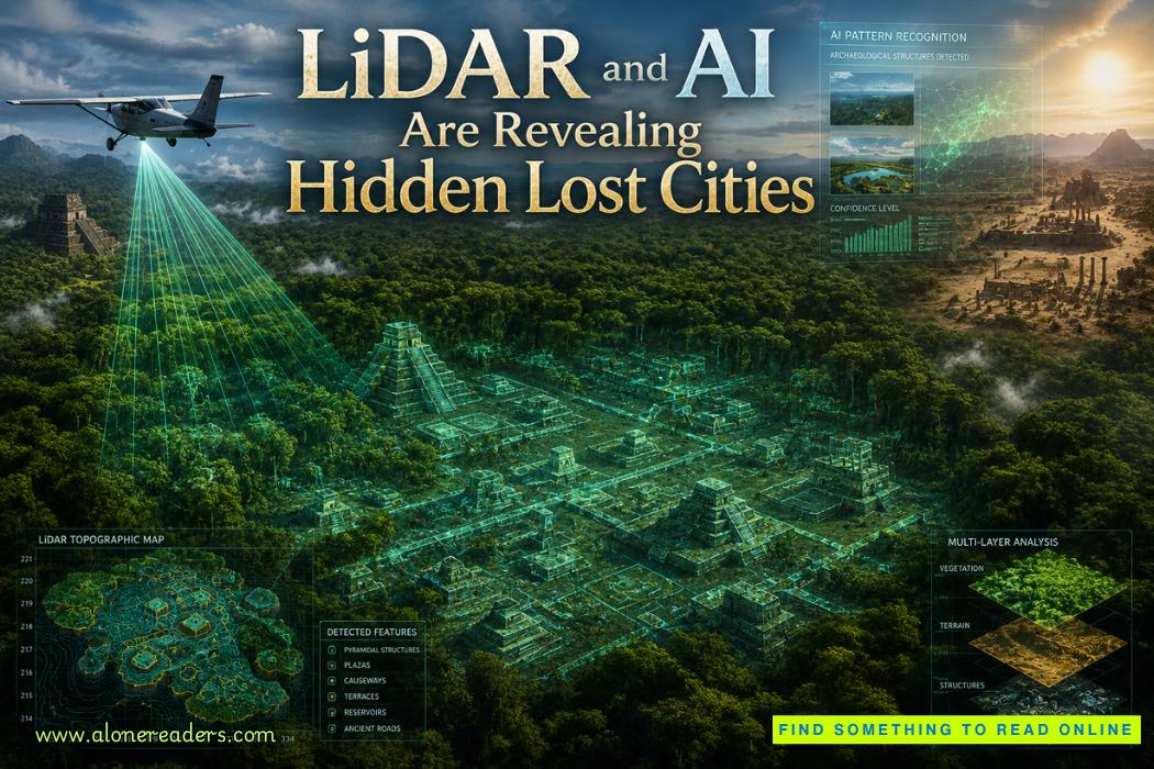
Today, archaeologists can scan thousands of square kilometers in days. Instead of relying solely on excavation, they increasingly use lasers, satellites, machine learning systems, and advanced data analysis to reveal landscapes that have been concealed for centuries. The modern search for a LiDAR lost city is no longer limited by dense jungle canopies, inaccessible terrain, or vast deserts. Technologies that originated in aerospace engineering, autonomous navigation, and artificial intelligence are transforming how humanity investigates its past.
The result has been extraordinary. Hidden cities under jungle vegetation, forgotten road networks, massive agricultural systems, and previously unknown settlements are emerging from data rather than from trenches. Yet these discoveries are also raising important questions about how archaeological evidence should be interpreted and how scientific caution should balance public excitement.
Key Takeaways
The traditional archaeological approach
For most of archaeological history, discoveries began with physical exploration. Researchers surveyed terrain on foot, analyzed historical records, interviewed local communities, and conducted targeted excavations.
While this approach remains essential, it has limitations. Dense forests can completely hide ancient settlements. Desert sands can bury entire urban centers. Mountainous terrain may be inaccessible for detailed field surveys.
A settlement extending across hundreds of square kilometers might leave only subtle traces visible from ground level.
The landscape archaeology revolution
Modern archaeology increasingly focuses on entire landscapes rather than individual sites.
Instead of asking, "Where was the city?" researchers ask broader questions:
Answering these questions requires seeing the bigger picture, which is precisely where LiDAR and AI excel.
A simple explanation
LiDAR stands for Light Detection and Ranging.
The technology works by sending millions of laser pulses toward the ground from aircraft, helicopters, or drones. Each pulse reflects back to a sensor, allowing computers to calculate precise distances.
The result is an incredibly detailed three-dimensional map of the landscape.
Why forests are no longer an obstacle
The most remarkable aspect of LiDAR is its ability to penetrate vegetation.
While many laser pulses bounce off leaves and branches, some reach the ground. Sophisticated software separates vegetation from terrain, effectively removing the forest digitally.
What remains is a high-resolution model of the land surface.
Features invisible to the human eye suddenly become obvious:
Entire urban layouts can emerge from what previously appeared to be untouched wilderness.
The data challenge
A modern LiDAR survey can generate billions of data points.
Reviewing every feature manually would take years.
This is where AI archaeology discoveries are making a profound impact.
Pattern recognition at scale
Machine learning algorithms excel at recognizing patterns.
Researchers train AI systems using known archaeological examples. The software learns the characteristics of ancient roads, settlement mounds, defensive structures, and agricultural terraces.
Once trained, AI can scan enormous datasets and highlight features likely to be human-made.
Instead of examining every square meter manually, archaeologists can focus on the most promising locations.
Combining multiple technologies
Modern archaeological AI often integrates:
By combining these sources, AI can identify relationships that might otherwise remain hidden.
The result is a dramatic increase in efficiency and discovery potential.
The misconception of an empty Amazon
For decades, many researchers believed large portions of the Amazon Basin were sparsely populated before European contact.
Dense rainforest appeared to support only small and scattered communities.
Recent discoveries have challenged that assumption.
Ancient urban networks
LiDAR surveys have revealed extensive settlement systems throughout parts of the Amazon.
Researchers have identified:
These findings suggest sophisticated societies capable of modifying entire landscapes.
Rather than isolated villages, some regions appear to have contained interconnected population centers linked through engineered transportation corridors.
The discoveries demonstrate how technology is reshaping understanding of ancient human settlement patterns.
One of archaeology's most dramatic transformations
Among the most famous examples of a LiDAR lost city investigation are recent studies in the Maya world.
The tropical forests of Central America conceal countless archaeological remains beneath dense vegetation.
Traditional surveys often required years of difficult fieldwork.
LiDAR changed everything.
A hidden urban world
Large-scale scans revealed extensive networks of:
Many structures had been completely hidden from view.
Perhaps most surprising was the scale of connectivity.
Rather than isolated ceremonial centers surrounded by wilderness, many Maya regions appear to have formed highly integrated urban landscapes.
Road systems linked settlements across vast distances, suggesting population densities far greater than previously estimated.
The discoveries continue to reshape understanding of Maya political organization, warfare, agriculture, and urban planning.
The challenge of arid environments
Jungles are not the only places where ancient settlements disappear.
Deserts create their own obstacles.
Wind-blown sand can bury roads, walls, irrigation systems, and entire towns.
Remote sensing in desert landscapes
Modern remote sensing technologies have revealed remarkable features across arid regions.
Researchers use combinations of:
Ancient caravan routes, irrigation networks, and settlement clusters have emerged from landscapes once assumed to be largely empty.
In many cases, subtle variations in elevation visible only through digital analysis reveal traces of long-abandoned human activity.
These discoveries highlight the growing importance of satellite archaeology as a complementary tool alongside LiDAR.
Technology finds possibilities, not answers
One common misconception is that AI automatically discovers lost civilizations.
The reality is more nuanced.
AI identifies patterns that may indicate archaeological features.
Human experts must still determine whether those patterns truly represent ancient structures.
Natural formations can sometimes resemble roads, walls, or settlements.
False positives remain a significant challenge.
Excavation remains essential
Even the most sophisticated remote sensing system cannot determine:
These insights still require excavation, artifact analysis, and contextual interpretation.
Technology guides investigation; it does not replace scientific inquiry.
Misconception 1: Every discovery reveals a completely unknown civilization
Most discoveries expand knowledge of cultures already known to researchers.
New settlements often belong to established civilizations rather than previously unknown societies.
Misconception 2: LiDAR can see underground
LiDAR maps surface terrain.
It cannot directly image buried buildings beneath the soil.
Misconception 3: Hidden cities were completely forgotten
Many sites were never entirely lost.
Local communities often knew of their existence long before scientific surveys documented them.
Misconception 4: AI can instantly identify archaeological sites
AI generates probabilities, not certainty.
Verification remains a critical part of archaeological research.
The Amazon remains only partially explored
Large portions of the Amazon Basin remain poorly surveyed.
Future LiDAR campaigns may reveal additional urban networks and agricultural systems.
Southeast Asia offers enormous potential
Dense tropical forests across Southeast Asia likely conceal substantial archaeological landscapes.
Remote sensing technologies are expected to play a major role in future investigations.
Africa's archaeological potential
Many regions of Africa remain underrepresented in large-scale remote sensing projects.
Improved access to LiDAR and AI analysis could transform understanding of ancient settlement patterns across the continent.
Deserts and climate reconstruction
As remote sensing improves, researchers may identify ancient cities connected to environmental changes that altered human migration and settlement patterns.
These discoveries could illuminate how past societies adapted to climate shifts, droughts, and resource challenges.
The next generation of archaeological research will likely involve increasingly sophisticated integration between AI, LiDAR, satellites, drones, and predictive modeling.
Future systems may automatically identify probable settlement locations before surveys even begin.
Researchers are already developing algorithms capable of predicting where undiscovered sites may exist based on terrain, hydrology, vegetation patterns, and known historical settlement behavior.
As datasets expand, machine learning models will become increasingly accurate.
The search for hidden cities under jungle canopies and forgotten desert settlements may become faster, more precise, and more comprehensive than ever before.
Yet the most valuable aspect of these technologies is not simply finding more sites.
They allow archaeologists to understand ancient landscapes as interconnected systems rather than isolated ruins.
The image of archaeology as a discipline defined solely by shovels and excavation trenches is becoming outdated. Modern discoveries increasingly begin with lasers, algorithms, and digital terrain models. A single survey can reveal patterns across entire regions that would have taken decades to identify through traditional methods.
The combination of LiDAR and artificial intelligence is transforming the search for a LiDAR lost city, uncovering evidence of complex societies hidden beneath forests, deserts, and remote landscapes. These technologies are revealing that many ancient civilizations were larger, more interconnected, and more sophisticated than previously believed.
At the same time, scientific rigor remains essential. Not every anomaly is a city, and not every headline reflects the full complexity of archaeological evidence. The most exciting discoveries emerge when advanced technology and careful scholarship work together.
The coming decades will almost certainly bring new revelations. Somewhere beneath an unbroken jungle canopy, beneath drifting desert sands, or hidden within unexplored terrain, entire chapters of human history may still be waiting for a laser pulse and an intelligent algorithm to bring them back into view.
1. What is LiDAR in archaeology?
LiDAR is a remote-sensing technology that uses laser pulses to create highly detailed maps of the ground surface, even beneath dense vegetation. Archaeologists use it to identify ancient structures, roads, terraces, and settlements hidden from normal view.
2. How does AI help archaeologists find lost cities?
AI analyzes enormous datasets from LiDAR scans, satellite imagery, and aerial surveys. It can detect patterns that may indicate human-made structures, helping researchers identify potential archaeological sites much faster.
3. Can LiDAR see underground buildings?
No. LiDAR cannot see through the ground. It reveals surface features by removing vegetation digitally, making subtle archaeological remains visible.
4. Why are many lost city headlines exaggerated?
Many discoveries involve previously unknown settlements, road networks, or urban landscapes rather than entirely unknown civilizations. Scientific verification takes time and requires excavation.
5. Where are future LiDAR discoveries most likely to occur?
Researchers expect major discoveries in the Amazon Basin, Central America, Southeast Asia, parts of Africa, and arid desert regions where ancient settlements may remain hidden.

October 25, 2023

January 02, 2025


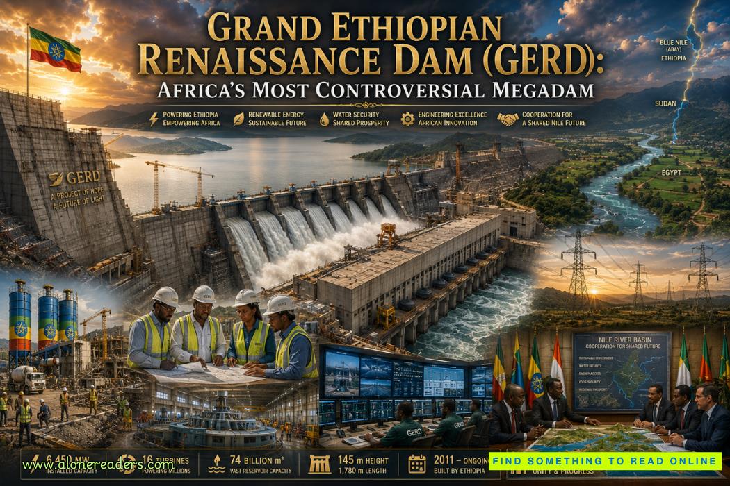 Grand Ethiopian Renaissance Dam (GERD): Africa's Most Controversial Megadam
 Aswan High Dam: Egypt's Modern Monument on the Nile
 Itaipu Dam: The Binational Wonder of Brazil and Paraguay
 Three Gorges Dam: China's Largest Engineering Project Explained
 Conwy Castle: The Masterpiece of Medieval Welsh Fortifications and Edward I's Mighty Fortress
 Caernarfon Castle: Edward I's Symbol of Conquest in Wales and a Masterpiece of Medieval Military Architecture
 The Battle of Tannenberg: Germany's Crushing Victory Over Russia in 1914
 The Eastern Front: Germany vs Russia in World War I
 The ANZAC Story at Gallipoli: Courage, Sacrifice, and National Identity
 The Gallipoli Campaign: Why the Allied Invasion Failed in World War I
 China R Visa High-Level Talent Permanent 2026: Complete Eligibility, Application Process, Benefits, and Long-Term Residence Guide
 China Family Visit Q Visa Surname Rules 2026: Complete Guide to Name Matching, Marriage, and Application Success
 Japan Digital Nomad Visa Pilot 2026 Rules: Complete Guide to Eligibility, Income, Application, and Stay
 Japan Working Holiday Visa Eligibility 2026: Complete Guide to Requirements and Who Can Apply
 The Impact of Exploration on Africa: Trade, Slavery, and Political Change During the Age of Discovery
 The Manila Galleon Trade: How the First Global Maritime Trade Network Connected Asia, the Americas, and Europe